
🌧️ Weather Modification Around the World in 2026: Who Seeds Clouds — and How?
Weather has always felt like one of the few things humans simply had to accept.
Rain arrives or it does not. Hail destroys a crop. Snowpack builds slowly. Drought stretches across another season.
But for decades, governments and organizations in parts of the world have experimented with something more ambitious: deliberately influencing local atmospheric processes.
The result is not one global weather-control system. It is a patchwork.
Some countries report operational cloud-seeding programs. Others experimented historically and stopped. Some use aircraft, others rockets, artillery or ground generators. Rain enhancement is the most familiar goal, but hail suppression also appears repeatedly. And across most of the world, publicly documented activity remains limited or absent.
These MAPTHOS maps visualize that fragmented geography.
Weather Modification Status: Most Countries Have No Documented Current Use
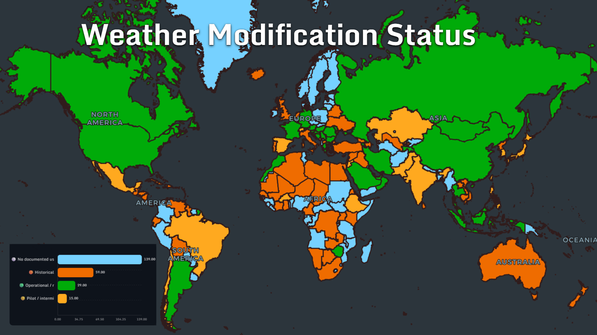
The first map asks the simplest question:
Where is weather modification actually used?The dataset divides countries into four broad categories:
- No documented use: 139
- Historical: 59
- Operational / recurring: 29
- Pilot / intermittent: 15
Weather modification is often discussed as though it were either science fiction or something happening everywhere. The map shows a much more nuanced reality.
The largest group consists of countries with no documented use in the dataset.
At the same time, operational or recurring activity appears across multiple regions, including parts of North America, South America, Europe, the Middle East and Asia.
A second layer consists of countries with historical programs. This suggests that weather modification is not simply a new technology spreading outward in a straight line. Some governments tested it decades ago, while others are experimenting with it now.
The geography is dynamic rather than universal.
Why Countries Modify Weather
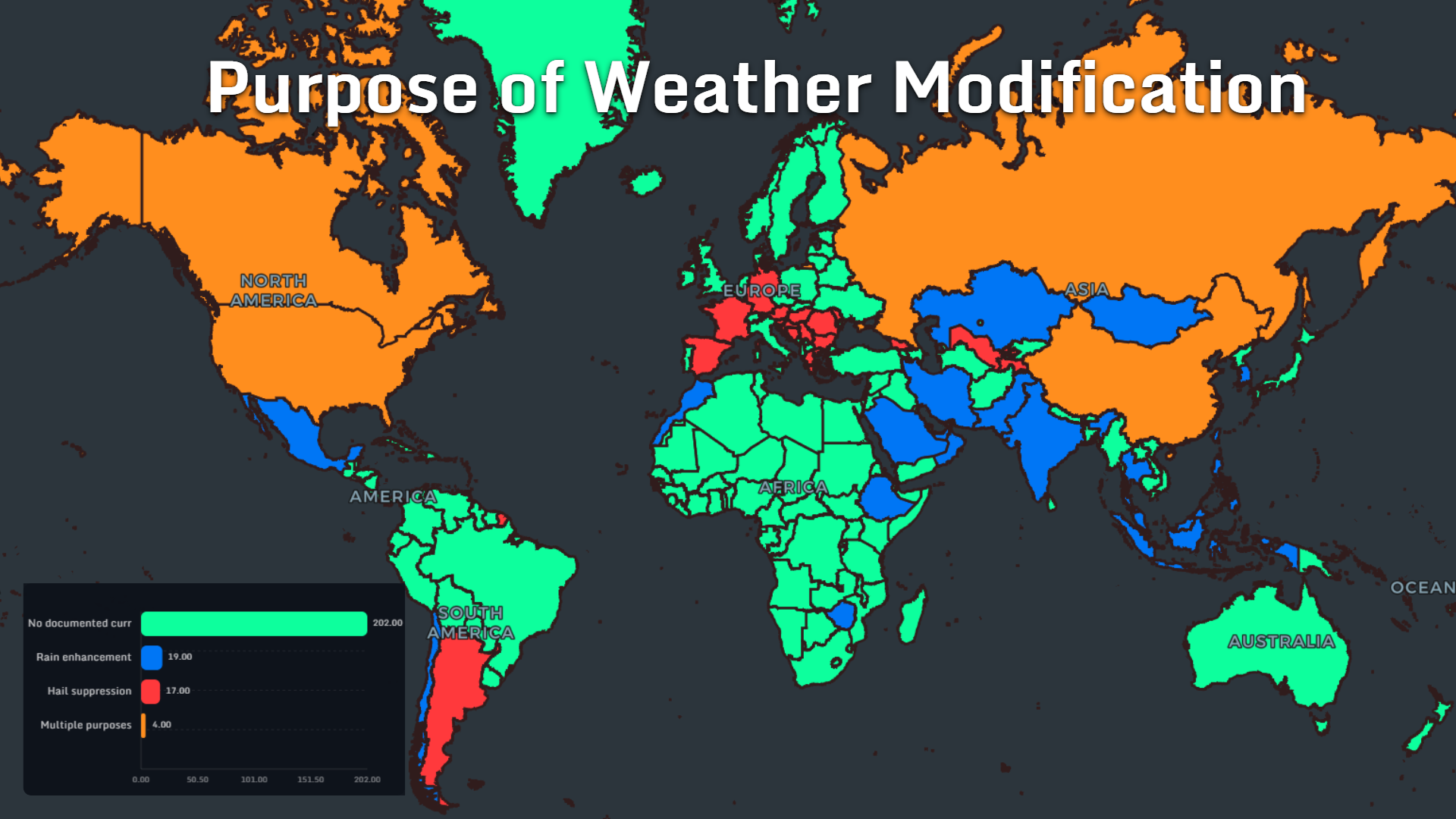
When documented programs exist, they are not all trying to achieve the same thing.
The mapped purposes include:
- Rain enhancement: 19 countries
- Hail suppression: 17
- Multiple purposes: 4
- No documented current purpose: 202
The basic idea is intuitive: under suitable atmospheric conditions, cloud-seeding operations attempt to encourage precipitation formation within existing clouds.
But hail suppression creates an entirely different geography.
Agricultural regions vulnerable to severe hail can have a strong economic incentive to experiment with atmospheric intervention. A short storm can destroy a season's crops in minutes, so even uncertain reductions in hail damage can become attractive enough to justify a program.
The map therefore reveals two different motivations behind the same broad technology:
create more precipitation — or reduce destructive precipitation.What Is Actually Put Into the Clouds?
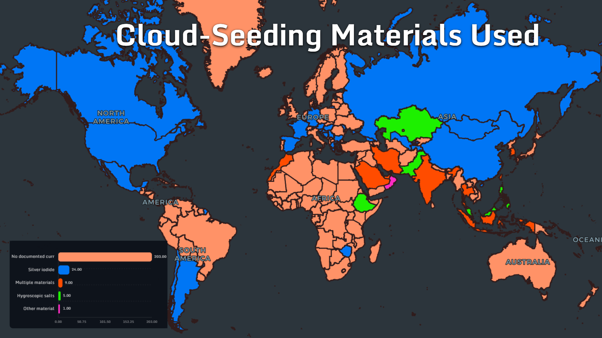
“Cloud seeding” sounds like one technique.
It is not.
The materials map shows several approaches:
- Silver iodide: 24 countries
- Multiple materials: 9
- Hygroscopic salts: 5
- Other material: 1
- No documented current material: 203
Its geographic footprint stretches across countries in several different climatic regions, showing that there is no single “cloud-seeding belt.”
Elsewhere, programs rely on hygroscopic salts or combinations of several materials.
That distinction is important because atmospheric modification depends heavily on the type of cloud being targeted.
There is no universal substance that can simply be released into any sky and produce rain.
The atmosphere still sets the conditions.
Aircraft, Rockets and Ground Generators
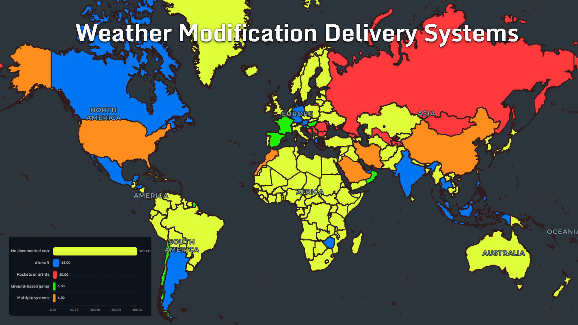
The delivery-system map is perhaps the most visually surprising.
Documented systems include:
- Aircraft: 15 countries
- Rockets or artillery: 10
- Ground-based generators: 6
- Multiple systems: 6
- No documented current system: 205
That is probably also the image most people associate with cloud seeding: a plane flying into or around suitable cloud systems and releasing a seeding agent.
But the map shows that this is only one method.
Some countries have documented the use of rockets or artillery, while others rely on ground-based generators that introduce seeding particles into air currents from the surface.
The technology can therefore look dramatically different from country to country.
One weather-modification operation may resemble aviation.
Another may look much closer to an artillery or launch system.
How Transparent Are Weather Modification Programs?
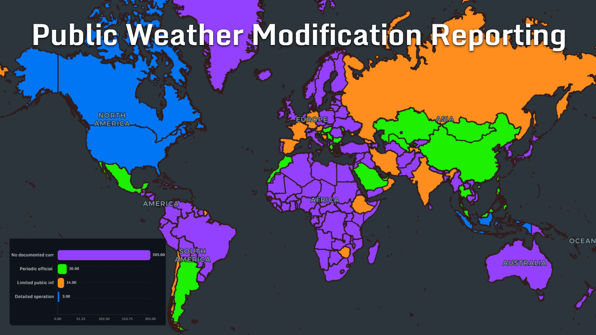
Perhaps the most important map is not about technology at all.
It is about information.
Public reporting falls into four categories:
- No documented current reporting: 205
- Periodic official reporting: 20
- Limited public information: 14
- Detailed operational reporting: 3
That gap helps explain why weather modification attracts so much speculation.
The technology is real.
The terminology is technical.
Programs can involve aircraft, chemical agents, military-style equipment and government agencies.
And in many countries, public information is sparse.
That combination creates almost perfect conditions for misunderstanding.
The map therefore raises a question that is as political as it is scientific:
If governments alter atmospheric processes, how much information should citizens be able to access about those operations?Weather Modification Has a Military History
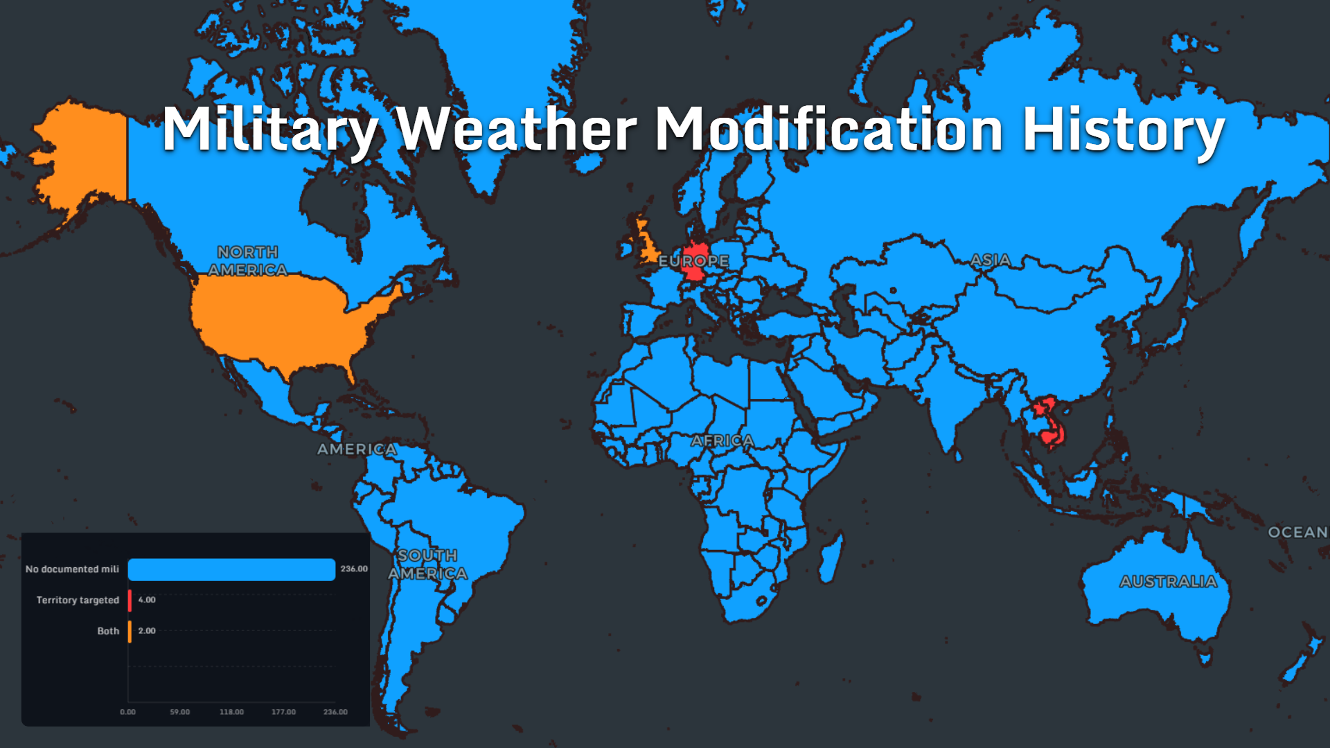
Civilian rain enhancement is only part of the history.
The military map shows a much smaller but important set of documented cases:
- No documented military history: 236
- Territory targeted: 4
- Both: 2
But the existence of even a small number of historical cases changes how the subject is perceived.
Weather modification sits in an unusual category: technologies developed for agriculture, water management or hail suppression can exist alongside historical attempts to study atmospheric effects for strategic purposes.
That does not make every modern cloud-seeding program military.
It does help explain why the topic attracts persistent geopolitical interest.
Declassified Atmospheric Dispersion Tests
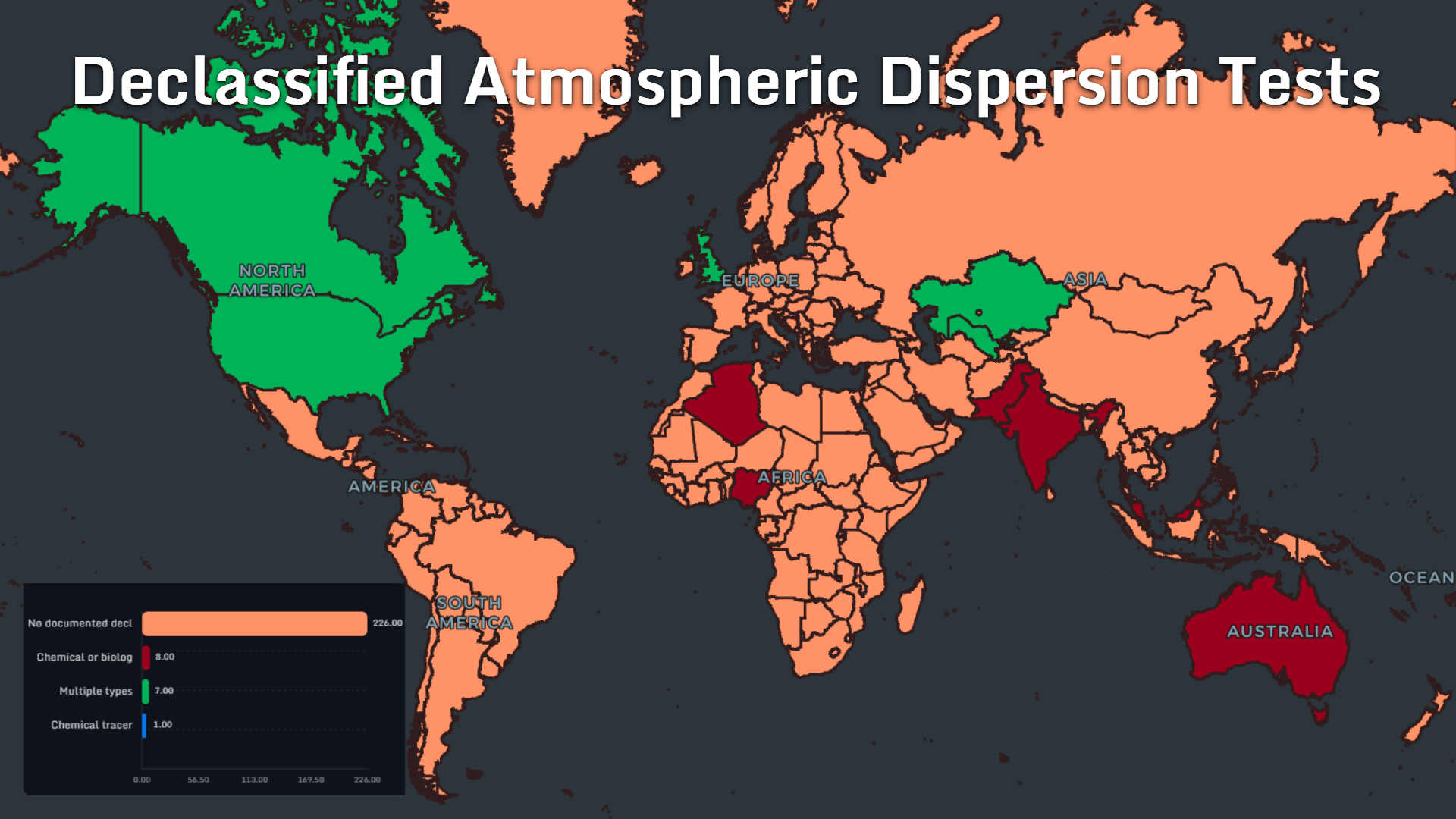
A related map looks at declassified atmospheric dispersion tests.
The categories shown are:
- No documented declassified tests: 226
- Chemical or biological: 8
- Multiple types: 7
- Chemical tracer: 1
But visually, they add another layer to the history of atmospheric experimentation.
Dispersion testing and cloud seeding are not identical activities, and they should not be treated as interchangeable.
What connects them is the atmosphere itself.
Governments have long been interested in understanding how particles, tracers and aerosols move through air — sometimes for meteorology, sometimes for defense research, and sometimes for entirely different scientific purposes.
A map makes those otherwise separate histories easier to compare without collapsing them into a single category.
The Difference Between Weather Modification and “Controlling the Weather”
One of the easiest mistakes is to treat every form of atmospheric intervention as the same thing.
They are not.
The maps describe technologies such as cloud seeding, rain enhancement and hail suppression.
These techniques work within existing atmospheric conditions.
They do not imply the ability to manufacture hurricanes, steer major storm systems across continents or arbitrarily create rain from a clear sky.
That distinction is central to understanding the subject.
Weather modification is better thought of as attempting to influence specific physical processes inside suitable weather systems, not commanding the atmosphere.
Even the name can make the technology sound more powerful than it actually is.
Why the Map Looks So Uneven
The global geography of weather modification is strikingly irregular.
There is no simple divide between rich and poor countries.
There is no purely East-versus-West pattern.
There is no single climatic zone where every government adopts the technology.
Instead, programs tend to emerge where several factors overlap:
water scarcity, agricultural exposure, suitable cloud conditions, technical capability, political willingness and enough economic incentive to justify experimentation.That is why neighboring countries can have completely different policies.
One may operate aircraft regularly.
Another may have abandoned its program decades ago.
A third may have no documented program at all.
The atmosphere may cross borders freely.
Weather policy does not.
The Transparency Gap May Matter More Than the Technology
The most striking number across these maps may not be the number of countries using silver iodide or aircraft.
It may be the number with little documented public reporting.
Weather modification occupies an unusual place in public imagination because it combines an invisible process with highly visible equipment.
A plane releases particles into a cloud.
A rocket enters the sky.
A ground generator emits material into the air.
Then rain either falls — or it does not.
For people outside the program, cause and effect can be extremely difficult to evaluate.
That makes transparent reporting especially valuable.
Where programs exist, publishing operational dates, materials, objectives, geographic boundaries and evaluation methods can help separate documented activity from speculation.
A Planet Experimenting With the Sky
The maps reveal something more interesting than a list of countries using cloud seeding.
They reveal multiple histories of humanity trying to negotiate with weather.
Sometimes the motivation is drought.
Sometimes agriculture.
Sometimes hail.
Sometimes scientific experimentation.
And historically, sometimes military strategy.
Most of the world still has no documented current weather-modification program in these datasets. But the countries that do participate use surprisingly diverse tools, materials and policies.
That makes weather modification a perfect subject for geographic visualization.
The question is not simply:
“Does cloud seeding exist?”It does.
The better questions are:
Where is it used? For what purpose? With what material? Using which delivery system? And how much does the public know about it?Put those questions on maps, and a subject usually trapped between technical reports and internet speculation becomes much easier to understand.
👉 Explore more at app.mapthos.org
See the world. Map better. Dream big. 🌍✨