💧 Global Water Stress in 2026: Who Has Water, Who Uses It and Who Is Running Out
Water rarely announces a crisis with a single dramatic moment.
More often, the warning appears quietly: a deeper well, a more expensive hotel room, a new desalination plant, a golf course watered under a hotter sky, or a farmer competing with a growing city for the same river.
The maps below tell that story at a planetary scale. Together, they show not one global water crisis, but several overlapping ones—shaped by climate, agriculture, tourism, geography, infrastructure and political borders.
The Global Water Stress Map in 2026
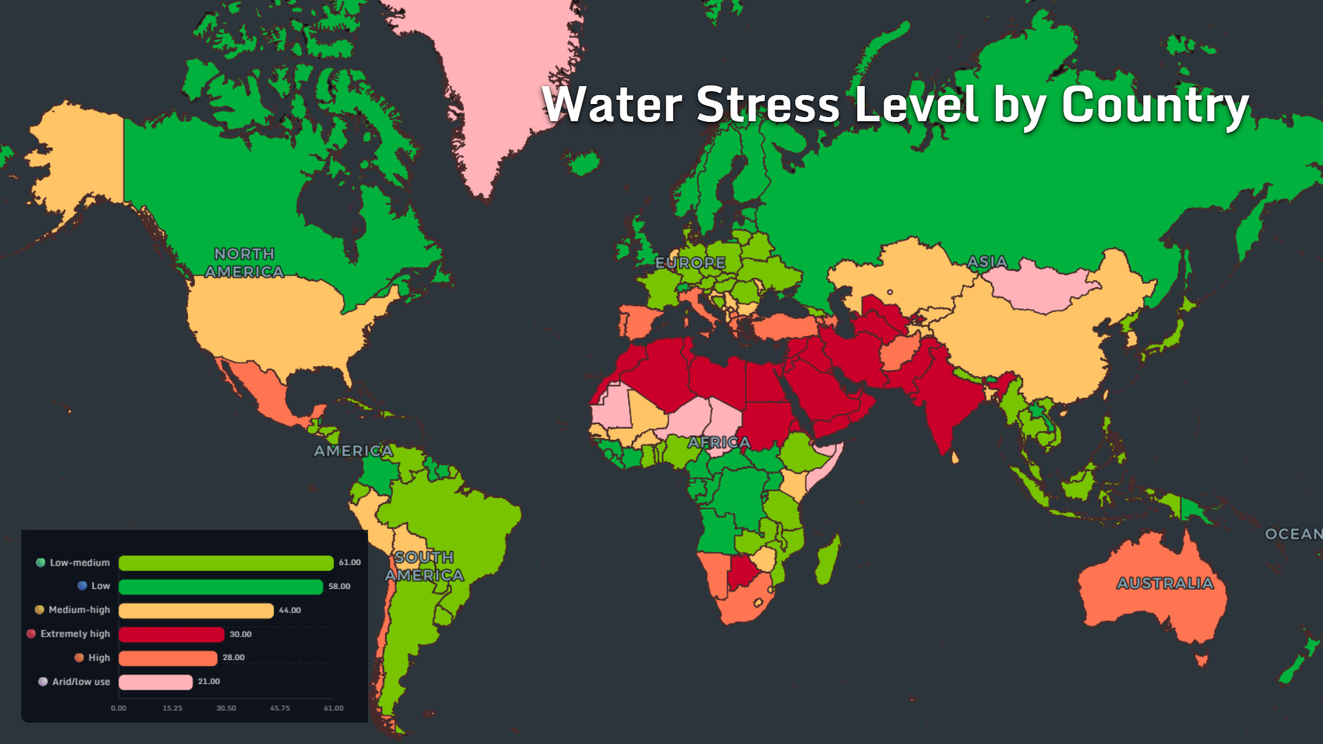
The opening map divides the world into six broad water-stress categories.
Across the supplied dataset:
- 61 countries or territories fall into the low-to-medium category
- 58 are classified as low stress
- 44 face medium-to-high stress
- 30 experience extremely high stress
- 28 are classified as high stress
- 21 are arid or show low water use
The geographic pattern is unmistakable.
North Africa, the Middle East, Central Asia and parts of South Asia form the most concentrated belt of severe pressure. These regions combine dry climates with rapidly growing cities, irrigation demand and limited renewable water supplies.
By contrast, Canada, Russia, parts of Northern Europe, equatorial Africa and sections of South America appear considerably less stressed.
But national averages can hide local realities. A country may look water-secure while individual cities, farming regions or aquifers experience serious shortages.
This is why a global water stress map is best read as the beginning of the story—not the conclusion.
> Data note: The values and category counts in this article are reproduced from the supplied MAPTHOS datasets. Where a chart does not specify a unit, its numbers are treated as comparative values on the original map scale.
Agriculture Consumes Nearly All Withdrawn Water in Some Countries
In many countries, the largest water user is not the household, factory or hotel.
It is agriculture.
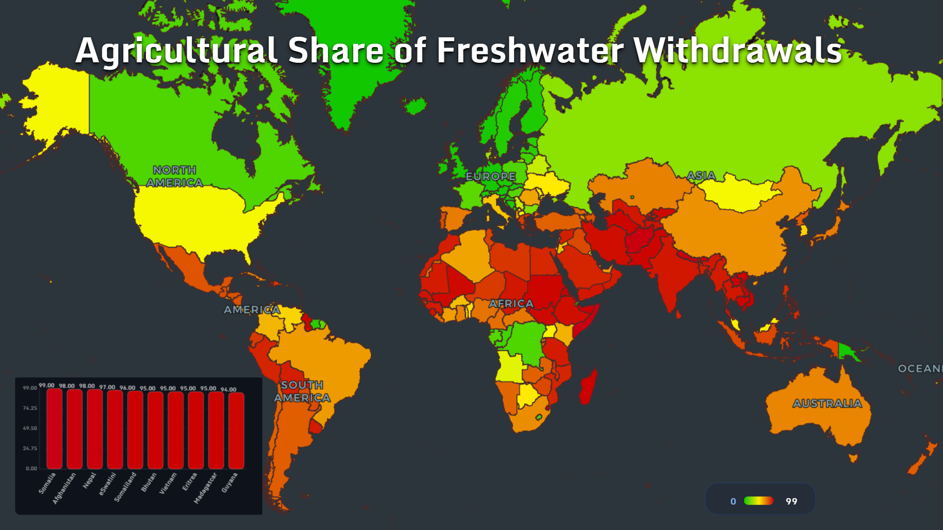
The highest agricultural shares of freshwater withdrawals in the dataset are:
- Somalia: 99%
- Afghanistan: 98%
- Nepal: 98%
- Eswatini: 97%
- Somaliland: 96%
- Bhutan: 95%
- Yemen: 95%
- Eritrea: 95%
- Madagascar: 95%
- Guyana: 94%
This concentration matters because agricultural demand is closely tied to food security. Reducing irrigation is not as simple as asking households to take shorter showers. It can affect harvests, food prices, rural employment and national stability.
The map also reveals a deep geographic contrast.
Much of Europe and northern North America shows a lower agricultural share, while countries across South Asia, East Africa and the Middle East depend heavily on water-intensive farming systems.
In dry regions, this creates a difficult equation: agriculture requires more irrigation precisely where water is least abundant.
Borders Can Be as Important as Rainfall
Water security is not determined only by what falls from the sky inside a country’s borders.
Rivers cross frontiers. Lakes are shared. Mountain snowmelt may begin in one country and support farms or cities in another.
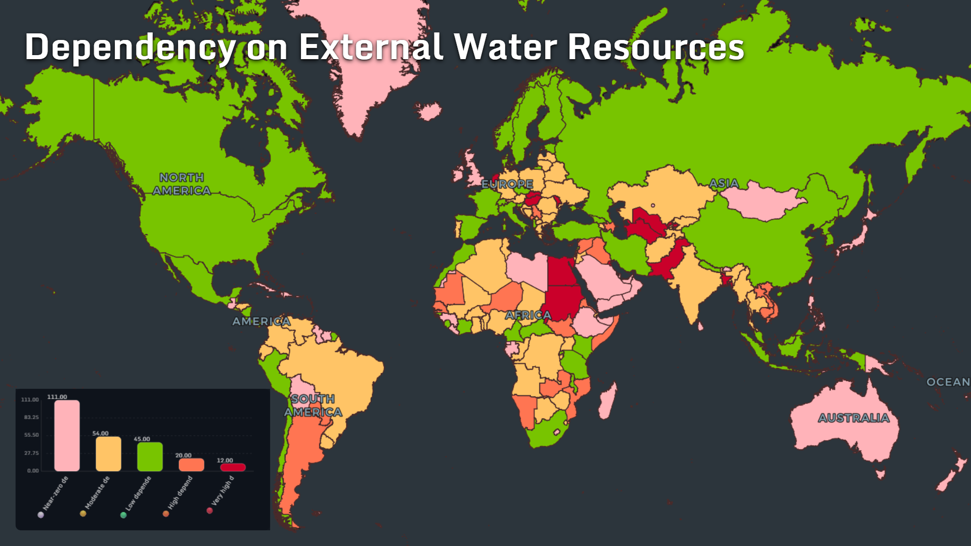
The external water dependency map classifies:
- 111 countries or territories as having near-zero dependency
- 54 as moderately dependent
- 45 as having low dependency
- 20 as highly dependent
- 12 as very highly dependent
The most vulnerable countries are often downstream states. Their water security depends partly on infrastructure, rainfall and policy decisions beyond their own borders.
That transforms water from a purely environmental resource into a diplomatic one.
A dam, irrigation project or extended drought upstream can reshape conditions hundreds or thousands of kilometres away. Cooperation becomes infrastructure: treaties, shared monitoring systems and reliable data can be as important as reservoirs.
The map reminds us that rivers do not recognize political borders, even when governments do.
Freshwater Abundance Is Unevenly Distributed
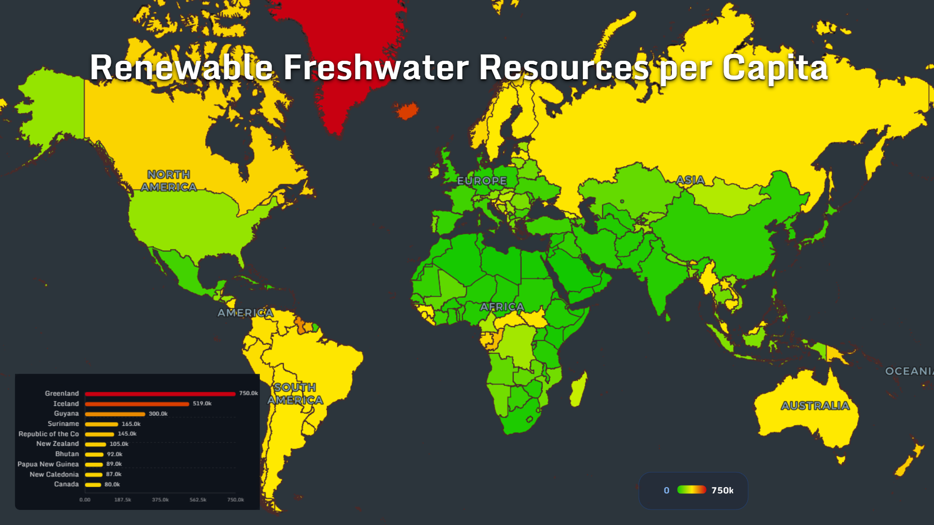
At the opposite end of the global water story are countries with extraordinary renewable freshwater resources per person.
The leading values shown on the map are:
- Greenland: 750k
- Iceland: 519k
- Guyana: 300k
- Suriname: 165k
- Republic of the Congo: 145k
- New Zealand: 105k
- Bhutan: 92k
- Papua New Guinea: 89k
- New Caledonia: 87k
- Canada: 80k
Most share a familiar set of geographic characteristics: small populations, high rainfall, major river systems, glaciers, extensive lakes or limited agricultural demand.
But water abundance does not automatically guarantee universal access.
A country may possess enormous freshwater resources while still facing remote communities, weak distribution infrastructure, contamination or seasonal shortages.
The map measures natural availability. Human access depends on what happens next: storage, treatment, transport and governance.
The Hidden Crisis Beneath Our Feet
Surface water can be seen.
Groundwater disappears more quietly.
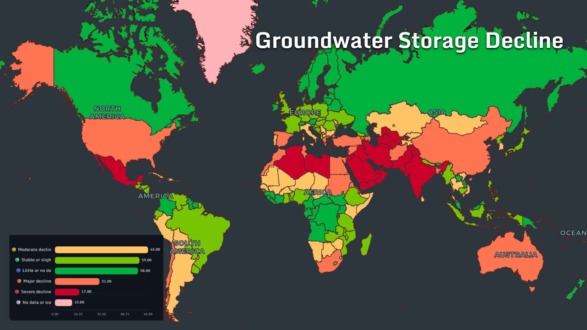
The groundwater storage map classifies:
- 65 countries or territories as experiencing moderate decline
- 59 as stable or showing only slight change
- 58 as having little or no decline
- 31 as experiencing major decline
- 17 as experiencing severe decline
- 12 as having no data or being dominated by ice
The most visible pressure zone stretches from North Africa through the Middle East into South and Central Asia. Mexico and parts of southern Europe also stand out.
Groundwater often acts as a hidden savings account. During droughts, farms and cities pump more from aquifers to compensate for reduced rainfall and river flow.
The danger begins when withdrawals consistently exceed natural recharge.
Water tables fall. Wells must be drilled deeper. Pumping becomes more expensive. Coastal aquifers may experience saltwater intrusion, while the ground itself can begin to sink.
Because the damage develops underground, the crisis may remain politically invisible until it becomes difficult—or impossible—to reverse.
Desalination Is Building a New Geography of Water
Some countries cannot wait for rainfall or aquifer recovery.
They manufacture freshwater from the sea.
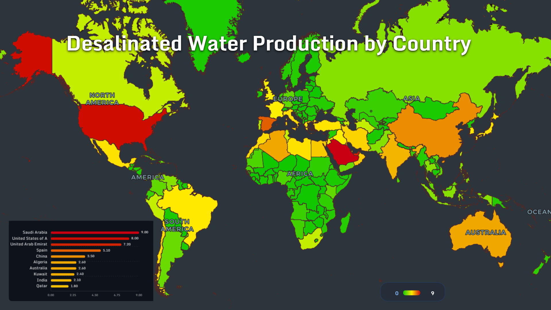
The leading desalinated water production values on the map are:
- Saudi Arabia: 9.0
- United States: 8.0
- United Arab Emirates: 7.2
- Spain: 5.1
- China: 3.5
- Algeria: 2.6
- Australia: 2.6
- Kuwait: 2.4
- India: 2.1
- Qatar: 1.8
The Middle East dominates the upper part of the ranking because desalination solves a fundamental geographic mismatch: large urban populations and economic activity located in extremely dry climates beside abundant seawater.
Spain and Australia demonstrate that desalination is not limited to desert states. It is also becoming part of drought resilience in developed coastal economies.
The technology comes with trade-offs. Desalination requires energy, significant infrastructure and careful management of concentrated brine.
Yet as climate variability increases, it is becoming less of an emergency measure and more of a permanent component of national water systems.
Wastewater Is Becoming a Resource, Not an Endpoint
The traditional urban water model is linear:
Extract water, use it, treat it and discharge it.
Water-stressed countries are replacing that model with a circular one.
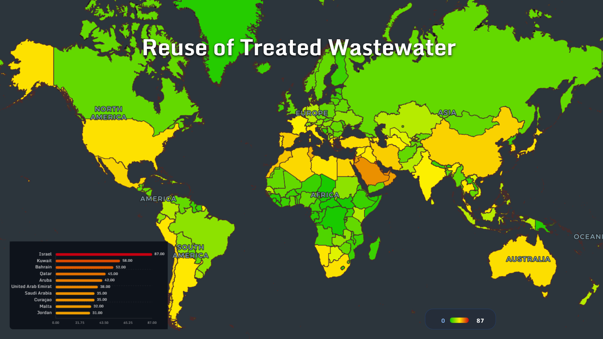
The leaders in treated wastewater reuse are:
- Israel: 87
- Kuwait: 58
- Bahrain: 52
- Qatar: 45
- Aruba: 42
- United Arab Emirates: 38
- Saudi Arabia: 35
- Curaçao: 35
- Malta: 32
- Jordan: 31
The geography is revealing. Many top performers are dry countries or small islands where freshwater is expensive, scarce or both.
Treated wastewater can support agriculture, landscaping, industrial processes and groundwater recharge. Every litre reused reduces pressure on rivers, reservoirs and desalination systems.
The cultural shift may be as important as the engineering.
Wastewater stops being viewed as something to remove and becomes a resource that has already been captured, transported and partially processed.
In a water-constrained future, the most resilient cities may not be those that find the most new water, but those that waste the least water they already have.
Tourism Can Concentrate Water Demand in the Driest Places
Tourists do not arrive evenly across a country.
They cluster in resorts, islands, historic cities and coastlines—often during the hottest and driest months of the year.
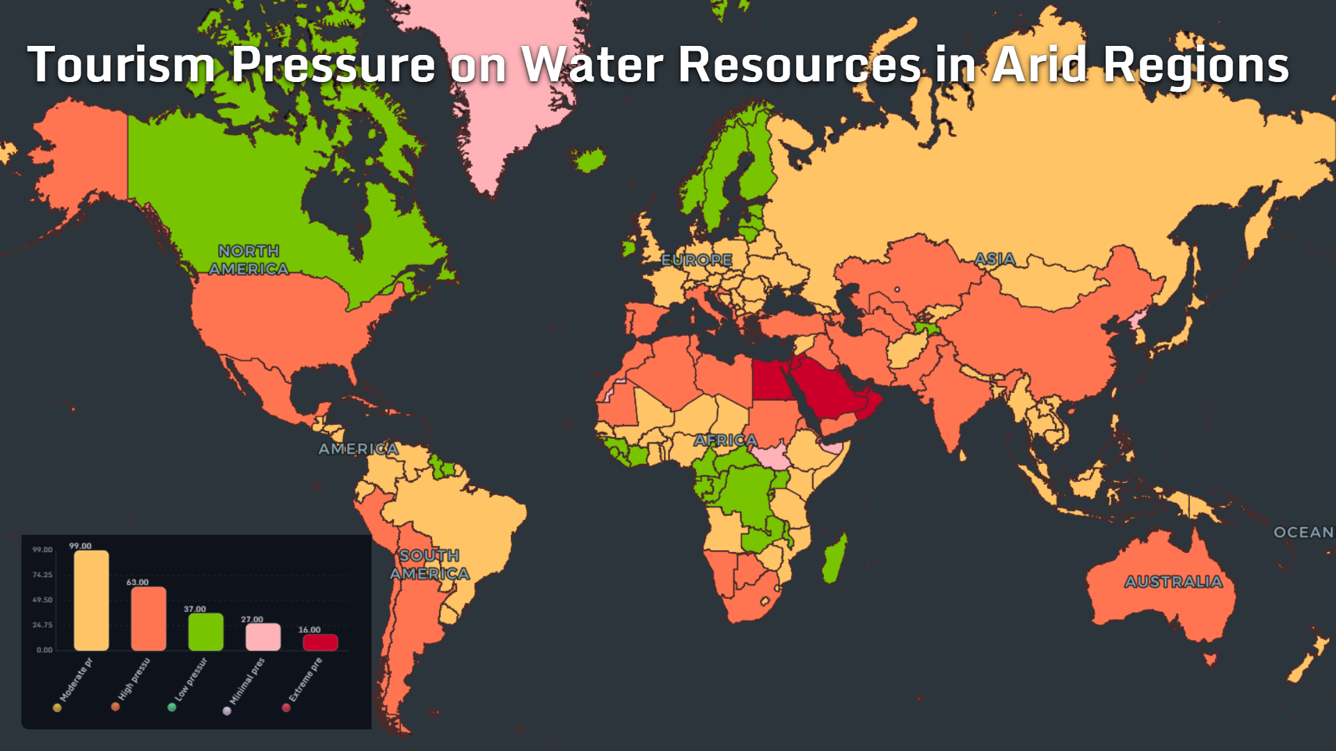
The tourism pressure map contains:
- 99 areas under moderate pressure
- 63 under high pressure
- 37 under low pressure
- 27 under minimal pressure
- 16 under extreme pressure
The pressure is strongest across the Middle East, North Africa, the Mediterranean, South Asia and parts of Australia.
Tourism can bring jobs, infrastructure and tax revenue. It can also create seasonal water demand that competes with local households and agriculture.
The ethical tension is simple: a visitor may experience an unlimited shower, landscaped hotel grounds and a full swimming pool in a region where nearby residents face restrictions.
Tourism’s water footprint is therefore not only about the total number of visitors. It is about where and when they arrive.
Hotels Turn Comfort Into Water Demand
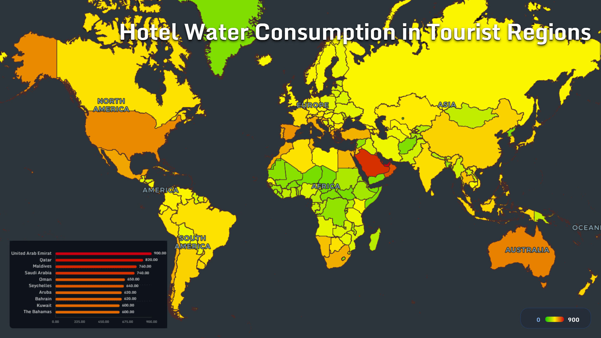
Hotels are small water systems of their own.
They provide rooms, laundries, kitchens, swimming pools, cooling systems, spas and landscaped grounds—often under the expectation that water should feel invisible and unlimited.
The highest hotel water-consumption values shown are:
- United Arab Emirates: 900
- Qatar: 820
- Maldives: 760
- Saudi Arabia: 740
- Oman: 650
- Seychelles: 640
- Aruba: 620
- Bahrain: 620
- Kuwait: 600
- The Bahamas: 600
Almost every country in the ranking is either arid, island-based or both.
This creates a paradox. Destinations with the least naturally available freshwater may offer some of the most water-intensive visitor experiences.
The solution is not necessarily less tourism. It is better systems: low-flow fixtures, wastewater reuse, smart irrigation, leak detection and transparent reporting of water intensity per guest night.
Luxury may eventually be redefined—not as using more resources, but as delivering comfort with far less waste.
Golf Courses Reveal the Geography of Optional Water Use
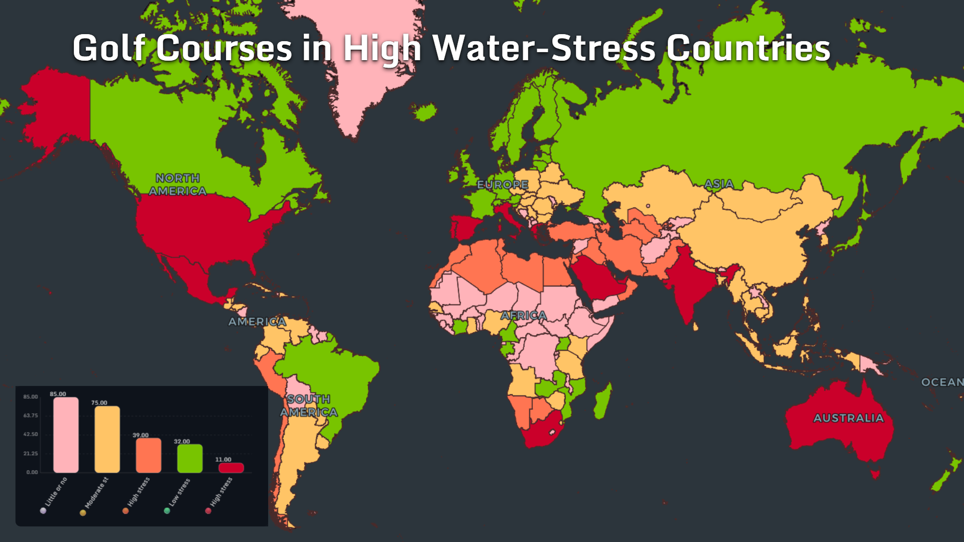
Golf is visually associated with green space.
That greenness can require substantial irrigation, especially in hot or arid climates.
The map groups countries into:
- 85 with little or no stress
- 75 with moderate stress
- 39 with high stress
- 32 with low stress
- 11 with extremely high stress
Some use treated wastewater. Others plant drought-resistant grass, reduce irrigated areas or rely on precision watering systems.
But the map raises a useful question: how should societies prioritize water used for recreation when essential demand is already under pressure?
This debate becomes particularly visible in the United States, southern Europe, the Gulf states, India, South Africa and Australia.
The most important distinction is not simply whether a golf course exists. It is which water source it uses.
A course irrigated with potable freshwater has a very different impact from one using recycled municipal water.
Lawns and Gardens Create a Domestic Water Footprint
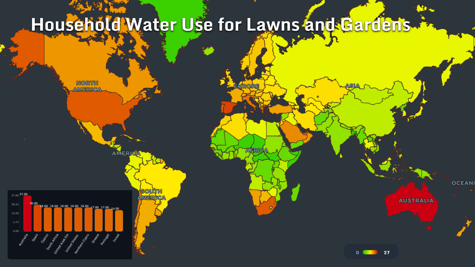
Outdoor household water use is often treated as a minor lifestyle issue.
At national scale, it becomes significant.
The leading values for household water used on lawns and gardens are:
- Australia: 27
- Spain: 20
- Cyprus: 18
- South Africa: 18
- United Arab Emirates: 18
- United States: 18
- Northern Cyprus: 17
- Greece: 17
- Portugal: 17
- Israel: 16
Most of the listed countries have hot summers, suburban development, private gardens or strong cultural expectations around green outdoor space.
Climate creates demand, but design determines how much water that demand requires.
Native plants, shaded soil, rainwater collection, efficient drip systems and reduced lawn areas can dramatically change domestic water consumption without eliminating gardens entirely.
The deeper question is aesthetic: should landscapes in dry climates be designed to look like wet ones?
What the Maps Reveal About the Future of Water
These maps do not show one simple division between water-rich and water-poor countries.
They show a far more complicated system.
Some countries possess abundant renewable freshwater but struggle to distribute it. Others have little natural water but build desalination and reuse systems sophisticated enough to support major cities.
Agriculture dominates withdrawals in one region. Tourism and landscaping intensify pressure in another. Groundwater masks shortages until aquifers begin to decline.
Three broad lessons emerge.
First, water scarcity is partly natural but increasingly shaped by human choices. Climate and geography establish the limits. Agriculture, urban design, tourism and infrastructure determine how quickly those limits are reached.
Second, technology can expand supply, but it cannot make water infinite. Desalination and wastewater reuse are powerful tools, yet both require energy, investment and effective governance.
Third, the most important water maps are comparative. Looking at stress alone is not enough. We must also map agriculture, tourism, groundwater, external dependency and adaptation.
That is where MAPTHOS becomes useful: not simply as a way to color countries, but as a tool for placing multiple global datasets beside one another until the hidden relationships become visible.
The future of water will not be decided by a single invention.
It will be shaped by millions of decisions about what we grow, where we build, how we travel and whether water is treated as a disposable input—or a resource that must keep circulating.
👉 Explore more at app.mapthos.org
See the world. Map better. Dream big. 🌍✨